Tanjung Putting National Park is a national park located on the southwest peninsula of Central Kalimantan province.
Tanjung Putting was originally a nature reserve and wildlife reserves with total area of 305,000 ha established by the Dutch East Indies government on June 13, 1936. Furthermore, on May 12, 1984 by Minister of Forestry, Tanjung Putting National Park is designated as the extent of the 415 040 ha.
Geographically situated between 2 ° 35'-3 ° 20 'South Latitude and 111 ° 50'-112 ° 15' E covering an area of Kumai district in the West and in the district Kotawaringin Hanau and Downstream Seruyan Seruyan District.
Tanjung Putting National Park is managed by the Tanjung Putting National Park, a technical implementation unit (UPT) Directorate General of Forest Protection and Nature Conservation (PHKA) Ministry of Forestry
Quote:
Tanjung Putting National Park has several ecosystem types consisting of lowland tropical rain forest, dry land forest, freshwater swamp forests, mangrove forest, beach forest and secondary forest.
This area is dominated by lowland forest plants such as jelutung (Dyera costulata), ramin (Gonystylus bancanus), meranti (Shorea sp.), Keruing (Dipterocarpus sp.), And rattan.
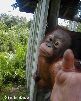
This type of endemic and endangered species found in protected forests of Tanjung Putting National Park, among others, the orangutan (Pongo pygmaeus), proboscis monkey (Nasalis larvatus), red monkey (Presbytis rubicunda rubida), bears (Helarctos malayanus euryspilus), deer (Tragulus klossi javanicus), clouded leopard (Neofelis nebulosa), and cats (Prionailurus borneoensis bengalensis).
Tanjung Putting National Park is the first location in Indonesia as an orangutan rehabilitation center. There are three locations for rehabilitation of orangutans at the Cape of Good Hope, Tanggui Cottage, and Camp Leakey.
Borneo Orangutan has a dark reddish fur and no tail. In line with the growth of his age, adult males develop cheek pads to form. The older, bigger cheek pads so impressed his face grim.
Tanjung Putting National Park as a Biosphere Reserve by UNESCO in 1977 and is the Sister Park with Malaysia.
Location: Central Kalimantan, Indonesia
Nearby cities: Bun Base
Coordinates: 2.9353 ° S 112.0402 ° BTKoordinat: 2.9353 ° S 112.0402 ° East
Area of 3.550 km ² (1370 mi ²)
Founded: 1982
Visitors: 2.046 (in 2007)
Management body: Minister of Forestry

Orang Utan di Taman Nasional Tanjung Puting


Tidak ada komentar:
Posting Komentar